Package
Introduction
|
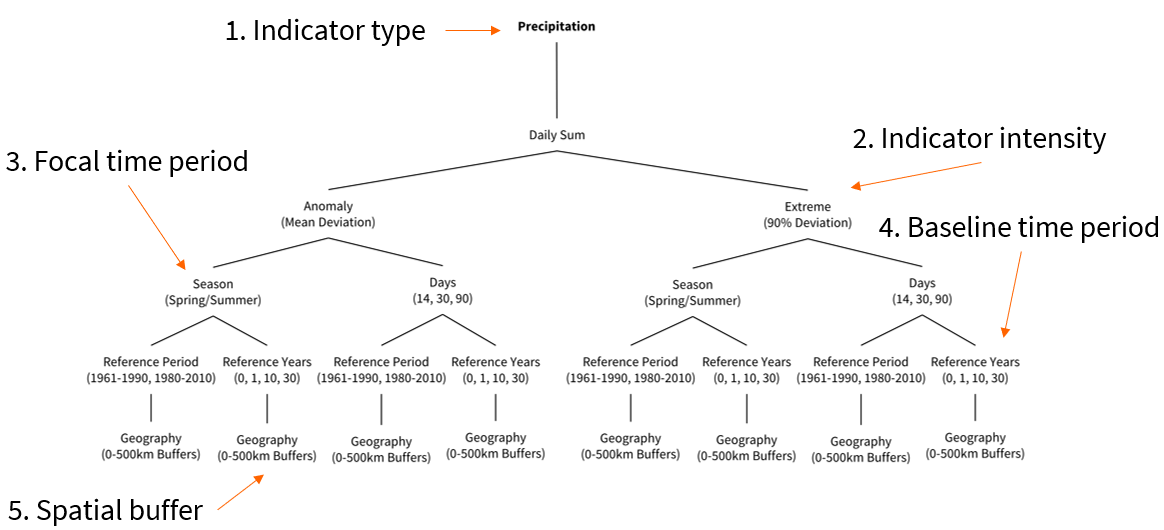
The unique feature of the tool should be the possibility of carrying out both geographically and temporally high-resolution queries of data from Copernicus and other Earth observation data sources, which at the same time function efficiently on simple workstations albeit large amounts of data. Our tested workflow development has identified five major levers: indicator type, indicator intensity, focal time period, baseline time period, and spatial buffer. Flexibility on these five attributes should be maximized for users. The tool also offers the functionality to automatically derive spatio-temporal links with other georeferenced data (e.g., surveys, digital behavioral data). |

|
Users should benefit from the core variables integrated into the interface for social research. Preparatory work is currently being carried out to select appropriate indicators from the corpus of indicators offered by data providers and conceptualize the data integration logic. Furthermore, in exchange with users and other stakeholders, we compile data products from EOD that are particularly relevant for social scientists. Examples include data on local air quality and pollutants, extreme weather events, or land use changes. The main data providers will be the Copernicus Monitoring Services on Climate Change, Atmosphere, and Land.
GESIS strongly supports the FAIR data principles and Open Data. The selection of R as the programming language for the tool supports open-source infrastructure development and shareability, as well as quality control via online repositories. Publishing the R scripts for data management and analysis ensures the reproducibility of all research steps.
Resampling and why it is useful
Resampling is a key step in correcting and aligning satellite or aerial images to real-world coordinates. It’s part of a broader process called geometric rectification, which transforms a distorted image (e.g., from 3D terrain or sensor angles) into a flat, properly aligned 2D map. After applying a mapping transformation—often based on ground control points (GCPs) with known geographic locations—resampling adjusts the pixel values to fit the new coordinate system. This creates a corrected version of the image where each pixel aligns with its real-world location.
Key features:
Combining different Earth Observation (EO) datasets
Integrating EO data with sociodemographic data (e.g., census, surveys)
Ensuring spatial accuracy for analysis (e.g., land cover with population data)
Documentation
Please check out the extensive documentation of the package at https://github.com/denabel/gxc.